January 18, 2005
The scenic route
 In a post on 1/15/2005 to the Risks Digest, under the heading "MapPoint explains Vikings?", Adam Shostack pointed out that
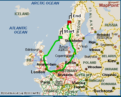
When going from Haugesund, Rogaland, Norway, to Trondheim, Sør-Trøndelag, Norway, be aware that following Microsoft MapPoint's directions, will take you through England, France, Belgium, the Netherlands, Germany, Denmark, Sweden, and finally back into Norway. While this may be culturally sensitive and respectful of historic Viking routing, rooting, or looting, it is somewhat less efficient than other routes, as a quick glance at a map will show.
Start: Haugesund, Rogaland, Norway
End: Trondheim, Sør-Trøndelag, Norway
Total Distance: 1685.9 Miles
Adam was following earlier directions from Nick Brown (or at least Nick's post to the same forum was earlier):
1. Go to http://mappoint.msn.com/DirectionsFind.aspx
2. In the Start section, select "Norway" from the listbox and enter "Haugesund" into the "City" field
3. In the End section, select "Norway" from the listbox and enter "Trondheim" into the "City" field
4. Click on "Get Directions"
MapPoint's point-by-point directions are fully up-to-date, so that the first three steps are
| Start: Depart Haugesund, Rogaland, Norway on 47 [Karmsundgata] (West) | 0.6 miles |
| 1: At roundabout, take the THIRD exit onto 47 [Djupaskarvegen] | 0.9 miles |
| 2: Road name changes to Garpeskjærvegen | 0.1 miles |
| 3: *Check timetable* Take Haugesund-Newcastle Upon Tyne (North-East) |
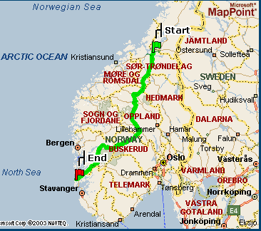 Well, the distances are in miles, but that is not an anachronism, but rather (I imagine) an automatic response to the IP address from which I made the query. If you ask for the route in the opposite direction, you get a less scenic and interesting answer, as shown in the picture on the right. In this case, the distance is given as 476.1 miles, or 1209.8 miles less.
I'm more sympathetic to such indirect navigation in weblog posts than in real-life journeys. When I've occasionally rented a car with a GPS-based navigation system, such as Hertz NeverLost, I've just entered the destination and followed the instructions without checking a map. Note to self: don't do this again.
[Risks Digest link via email from Fernando Pereira]
[Update: Nathan Vaillette wrote:
long time listener, first time caller, so to speak. Love your work.
Regarding the Haugesund--Trondheim itinerary: try the same search at mappoint, but asking for the "shortest route" rather than the quickest (by clicking the relevant button under "Route type" on the right). The result is less rococo but arguably more absurd.
(By the way, am I missing the language tie-in in that blog entry?)
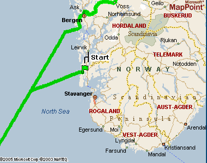 The "shortest route" is indeed very striking, since it involves taking the ferry from Haugesund to Newcastle Upon Tyne, and then turning right around and taking the ferry back from Newcastle Upon Tyne to Bergen. I guess that's one way to get around the fjords. This also suggests what might be wrong with the route-finding program -- perhaps it doesn't include water travel in its distance or time cost functions...
As for the missing language hook, I originally had two, one being the influence of Scandinavian on northern Middle English, and the other being the misplaced comma in Adam Shostack's original post. But I didn't have time to explain the first one before I had to get going on my morning obligations, and I decided that it would be ungracious to mention the second one. ]
[Update 1/19/2005: Thomas Paul writes with more information:
MapPoint seems to have fixed/broken the problem. If you try to create a route between the two cities you now get:
"A route between the locations you entered could not be calculated. One of the locations may not contain necessary connectors such as ferry routes or main roads. Please change one or both of the locations."
Yoiu get this no matter which city you make the starting point. My guess is that the problem was not caused by MapPoint not figuring in the time of the ferry (they correctly estimated the roundtrip as being 51 hours) but rather that they simply didn't have a route out of Haugesund, Rogaland. The only route they could find out of town was the ferry, although they did find a route into the city. Notice that the "Grand Tour" through Europe only took 48 hours which is why MapPoint took it as the "quickest" route rather than taking the ferry back to Bergen, Norway which takes 51 hours.
Hmm. MapPoint's own map certainly makes it seem that there are roads from Haugesund to the rest of Norway, but I guess appearances might be deceiving... ]
Posted by Mark Liberman at January 18, 2005 06:30 AM